Simulated CPT Points & Empirical Settlement Analysis
Overview
Cone Penetration Testing (CPT) stands as a cornerstone in geotechnical engineering, and with the growing reliance on CPT data, the challenge of dealing with missing or unrecorded points has become prevalent. The Simulated CPT Point feature addresses this concern by utilizing Gaussian Process Regression (enhanced by non-lattice sparse Bayesian learning algorithm) (Ching et al., 2021). This feature enables the generation of missing CPT points and facilitates empirical settlement predictions for the defined region.
Key Features
1. Simulated CPT Points
- Location Flexibility: Users can simulate CPT points at any location with a requirement of a minimum of two existing CPT points for accurate simulations.
- Algorithm Efficiency: The underlying algorithm, inspired by Ching et al. (2021), employs Gaussian process regression (enhanced by non-lattice sparse Bayesian learning algorithm) for analyzing site-specific CPT data, effectively determining missing data points.
2. Empirical Settlement Analysis
- Schmertmann's Method: Simulate empirical settlement along the depth of CPT-simulated points, providing critical insights into soil behavior.
- User-Defined Settings: Users can fine-tune simulation settings for coarse, medium, or fine accuracy, balancing computational efficiency with precision.
Workflow
- Project Settings:
- Units: The simulated CPT points will follow the same units the users define in the project settings.
- Soil Profile: In soil profiles tab, either horizontal soil layers should be selected or non horizontal layers without non-horizontal ground surface enabled. this feature will not work for non-horizontal ground surface.
- Cone Penetration Test (CPT): The user needs to have CPT Analysis option enabled in the Project Settings.
- CPT Tab Activation: Navigate to the CPT tab. There should be at least two CPT points in order to use the feature. After this condition, then the CPT simulation tabs becomes enabled. Also, the CPT points needs to be realistic and should have sufficient points for the simulation.
- Simulate CPT: Use the simulation tabs to generate CPT points and simulate empirical settlement. Users have the flexibility to choose simulation settings based on project requirements. The available parameters to simulate are qc, fs, u2 with density along the depth of soil with coarse, medium, and fine options.
These settings can be applied separately for any CPTs defined, and for CPT settlement region. The project requirements are explained more in details on the CPT Simulations Settings help page.
- Results
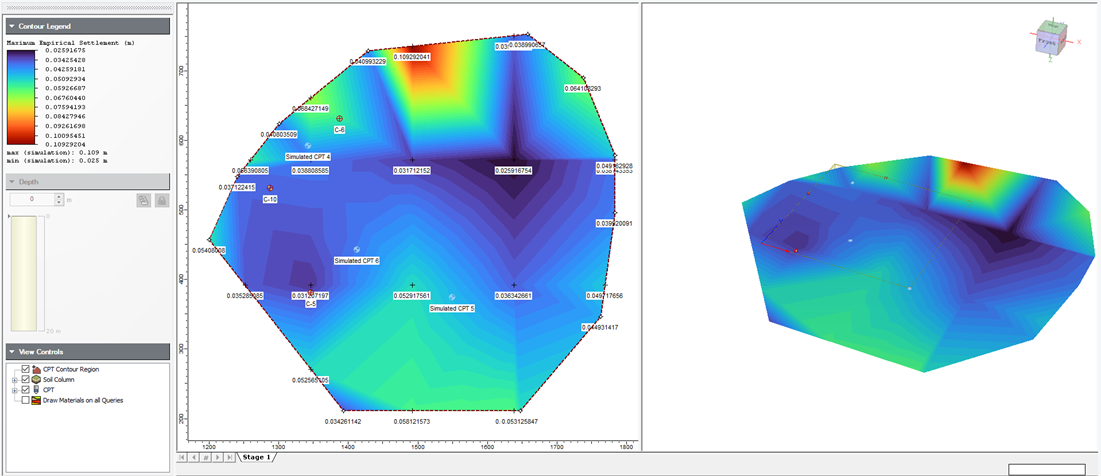
- View results (Contour Mapping): Explore settlement regions with contour maps based on simulated qc or unit weight at specified grid points.

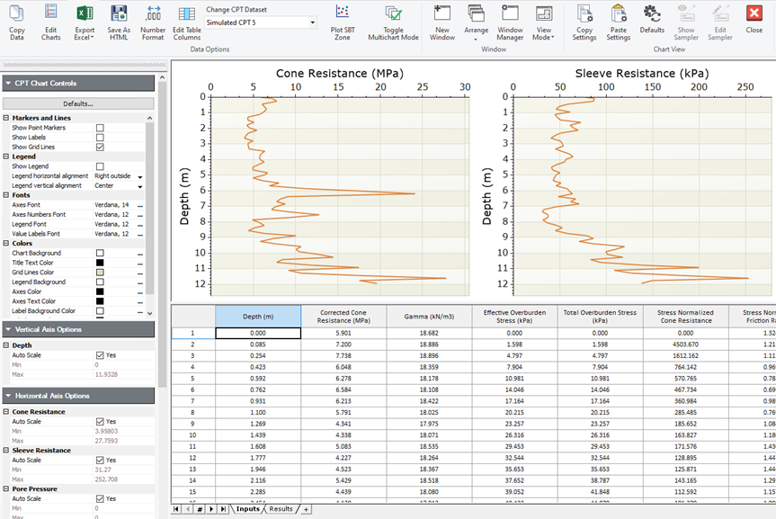
- Graph CPT (visualization of CPT simulated points): Right-click on CPT simulated points to visualize them along the depth of the soil. Note that these are average values of all the simulations.

- You can also export all of the simulations by Selecting Export Excel > Export simulations. Note that this is only available after compute. Closing the file will not save all the simulations but it will only save the average of all the simulations.
Best Practices
⦁ Simulation Settings: Adjust simulation settings based on the desired balance between computation time and accuracy.
⦁ Verification: While the algorithm approximates missing data points, users are encouraged to verify results and check the range of simulated outcomes.
Example Applications
- Settlement Analysis: Conduct settlement analysis for user-defined regions with varying grid points, allowing for worst, median, and best-case scenarios.
- Simulation Checks: Verify and compare simulated CPT points against known values to ensure accuracy.
- Deterministic Analysis: Perform settlement analysis in a Settle3 using the simulated CPT points as input.
With this feature, Settle3 provides a comprehensive solution for accurate and location-specific CPT data analysis, significantly enhancing the simulation of unknown CPT data points in projects.
References
Ching, J., Huang, W.H., and Phoon, K.K. (2020). 3D probabilistic site characterization by sparse Bayesian learning. ASCE Journal of Engineering Mechanics, 146(12), 04020134.
Ching, J., Yoshida, I., and Phoon, K.K. (2023). Comparison of trend models for geotechnical spatial variability: Sparse Bayesian Learning vs. Gaussian Process Regression. Gondwana Research, 123, 174-183.
Ching, J., Yang, Z.Y., and Phoon, K.K. (2021). Dealing with non-lattice data in three-dimensional probabilistic site characterization. ASCE Journal of Engineering Mechanics, 147(5), 06021003.
Yoshida, I., Tomizawa, Y., and Otake, Y. (2021). Estimation of trend and random components of conditional random field using Gaussian process regression. Computers and Geotechnics, 136, 104179.