Managing Coal Mine Slope Failures in South America and Australia With Slide3
Coal mines are highly susceptible to slope failures, as they face forces from anisotropic rock masses, weak clay seams, fluctuating groundwater pressures, and heavy rain. New research from N. Bar and J.C. Cobián shows how using the right software can effectively manage this risk.
They conducted failure back analyses on two coal mines using 3D slope stability modelling and radar monitoring, on top of remote sensing and traditional techniques like drill core logging. The two mines – one located in Australia and the other in South America – were safely managed, and the paper showed how the collected data can help mitigate future risk.
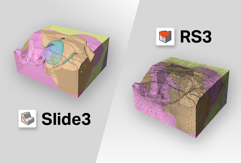
Here, we’ll highlight the original research findings and show how Slide3, our 3D limit equilibrium analysis software, was used.
The Geological Setting
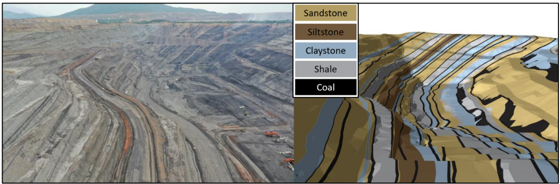
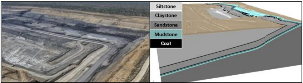
The two coal mines in the research operated in geologically complex environments, which presented unique challenges and opportunities for advanced slope stability analysis. The South American mine spanned a vast area, featuring multiple open pits each up to 300 meters deep and exploiting over 50 individual coal seams within an interbedded sequence of sandstone, siltstone, and claystone. The geological setting is characterized by moderately anisotropic rock masses, with an anisotropy index (Rc) ranging from 3 to 4, and the presence of shears developed on coal contacts due to minor folding.
The Australian mine had a new open pit extending 1 x 10 kilometers with low-wall bench heights of 20 meters and steep high-wall benches at 70° face angles. The stratigraphic sequence included weak clay seams at depths of 2 and 10 meters below the coal seams, which significantly impacted slope stability. The structural geology is relatively simple but had thin, weak clay seams that were critical interfaces in the stability models.
The Research Challenge
Both mining operations needed to manage semi-ductile slope failures in highly complex geological settings. Specifically, the South American mine dealt with multiple open pits exploiting over 50 individual coal seams within an interbedded sequence of sandstone, siltstone, and claystone, while the Australian mine featured steep, high wall benches and significant stratigraphic variations, including weak clay seams.
After analyzing data collected from these sites, researchers aimed to validate and refine the methods used to manage slope stability, further geotechnical understanding, and enhance the reliability of future design risk forecasts.
The Solution
Slide3’s 3D limit equilibrium (LE) analysis was the chosen solution, because the software allowed for:
- Detailed modelling of complex slope geometries.
- Incorporation of varying material strengths and anisotropic behaviors.
- Accurate simulation of groundwater conditions using advanced parameters.
In the South American mine, Slide3 was used to predict future potential multi-bench failures so geotechnical engineers could proactively manage risk. The software's ability to simulate groundwater conditions with precision using vibrating wire piezometer (VWP) data and Hu coefficients helped researchers understand pore pressure impacts on slope stability.
In the Australian mine, Slide3's 3D modeling capabilities were validated against real-time radar displacement data. This validation process involved iterative back-analysis and adjusting friction angles to match observed field data. The software's capability to model slip surfaces at varying depths allowed for the identification of both multi-bench and single bench failure mechanisms for a comprehensive understanding of potential instability issues.
The Results
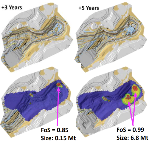
South American Mine: Slide3 accurately forecasted stability conditions for the life-of-mine (LoM) design. It identified a large low FoS area (FoS≈1.1) and several small potential failures (FoS<1) for the near future (1 to 3 years), allowing for minor design changes to manage risks while preserving coal recovery and enhancing safety.
For the longer term (5 to 10 years), the models predicted significantly larger failure volumes exceeding 6 million tonnes (FoS<1), which could have substantial economic impacts. Thankfully, these risks are several years away and there’s time for further site investigations and to further refine the design.
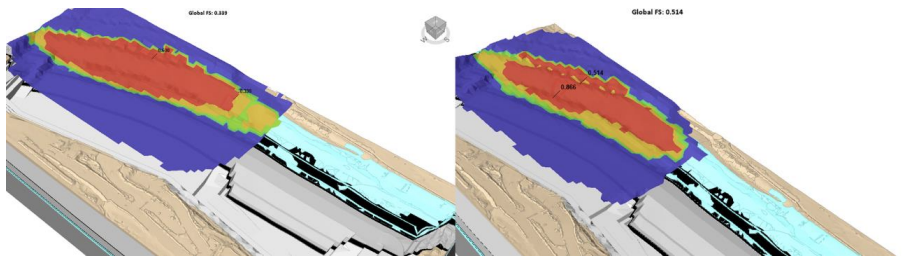
Australian Mine: Slide3's predictions were validated against radar displacement data for slope failure forecasts (see Figure 4). During a heavy rain event, a low-wall failure occurred with a friction angle of 17° for the clay seam, which was managed safely through radar. The FoS map researchers created in Slide3 was almost identical to the radar displacement map and confirmed the model's reliability.
Slide3’s LE model was also used to forecast the next phase of the mine (see Figure 5) and several instabilities were located. This process provided valuable data for decision making, particularly around improving stability and more thoroughly understanding the potential of costly productivity delays.
The Verdict
Overall, Slide3's precise modelling validated against radar data allows for proactive risk management, and in this case, it provided insight on a low-wall failure and identified future critical instability zones. Slide3 turned complex geological data into clear, actionable insights, proving its worth for improving safety and efficiency in mining.
Frequently Asked Questions About Coal Mine Slope Failures
What Can Cause Slope Failure in Open-Pit Coal Mines?
Slope failures in open-pit coal mines can be caused by anisotropic rock masses, weak clay seams, fluctuating groundwater pressures, heavy rain events and more; they create weak zones and instability within the slopes.
Anisotropic rock masses, for example, exhibit different strengths depending on the direction of loading and make certain orientations more susceptible to failure. Weak clay seams act as natural slip planes that reduce overall stability. Groundwater pressures can lead to increased pore pressure within the rock, which weakens the effective stress and promotes failure. Heavy rain can rapidly change groundwater levels and trigger sudden slope movements.
What are the Economic Impacts of Slope Failures in Coal Mining?
Slope failures can lead to significant economic losses due to halted production, costly remediation efforts, equipment damage, and potential loss of recoverable coal reserves. Interrupting mining operations directly impacts productivity and revenue because repair and stabilization take substantial resources.
Additionally, there could be further costs from equipment damaged or buried by slope failures. The necessity to re-evaluate and redesign slopes can delay mining schedules, and in severe cases, entire sections of the mine may become inaccessible, resulting in permanent loss of resources.
How Do Anisotropic Materials Affect Slope Stability Analysis?
Anisotropic materials, which have different strengths in different directions, can complicate slope stability analysis. They require advanced modeling to accurately predict how overall slope stability will be impacted.
Foliation, bedding planes, joint sets, and more can all result in anisotropy, which create planes of weakness within the rock mass. Accurate modelling requires detailed characterization and understanding of their directional properties, which often involves complex mathematical representations that geotechnical software like Slide3 can help you with.
How Can Coal Mines Proactively Manage Slope Stability Risks?
Some of the strategies coal mines can employ to proactively manage slope stability risks include using advanced 3D modeling and real-time radar monitoring, conducting thorough site investigations, and incorporating groundwater data to predict and mitigate potential failures.
Advanced 3D modeling helps simulate the complex geometries and varying material properties of the slopes for an accurate risk assessment. Real-time radar monitoring allows for continuous observation of slope movements that enables immediate responses to emerging hazards. Comprehensive site investigations provide you with critical data on geological conditions, and groundwater monitoring tracks changes in pore pressure that affect stability.
What Technologies are Used to Monitor Slope Stability in Mines?
Radar displacement monitoring, vibrating wire piezometers, photogrammetry, and laser scanning are all common technologies for monitoring slope stability because they provide real-time data for accurate analysis.
Radar displacement monitors detect minute movements within the slope and allow for early detection of potential failures. Vibrating wire piezometers measure pore water pressures, critical for understanding groundwater influences on stability. Photogrammetry involves capturing high-resolution images to create detailed 3D models of the slope surface, while laser scanning offers precise measurements of slope geometries.
How Does 3D Modelling Improve Mine Slope Stability?
3D modelling provides a detailed and realistic representation of slope geometry, material properties, environmental conditions, and more for more accurate stability predictions.
Unlike traditional 2D models, 3D models capture the complex interactions between different layers, structures, and forces within the slope. They can simulate various scenarios like different failure mechanisms and environmental changes to predict how slopes will respond.